


Australia, Indian Ocean, Territory of Cocos (Keeling) Islands, 1955, 1:63 360
Copyright Expired
![]() Download (5.62 MB)
Download (5.62 MB)
 Islands_63.36K__master.jpg)

| dc.coverage.spatial | Australia | |
|---|---|---|
| dc.coverage.spatial | Indian Ocean Islands | |
| dc.coverage.spatial | Cocos (Keeling) Islands | |
| dc.coverage.spatial | 1:63 360 | |
| dc.date.accessioned | 2020-05-13T06:42:36Z | |
| dc.date.available | 2020-05-13T06:42:36Z | |
| dc.identifier | 6307 | |
| dc.identifier.uri | http://hdl.handle.net/1885/204274 | |
| dc.format.extent | 6 MB| 1 map | |
| dc.format.extent | 61 MB|1 map | |
| dc.format.extent | 300 dpi | |
| dc.format.mimetype | image/jpg | |
| dc.format.mimetype | image/tiff | |
| dc.language.iso | en | |
| dc.publisher | Drawn for Dept of Territories by Division of National Mapping, Department of National Development, Canberra, ACT | |
| dc.rights | Copyright Expired | |
| dc.subject.other | Topography | |
| dc.subject.other | Australia -- Maps | |
| dc.title | Australia, Indian Ocean, Territory of Cocos (Keeling) Islands, 1955, 1:63 360 | |
| dc.type | Cartographic material | |
| local.description.notes | Accepted as a Territory of the Commonwealth of Australia, 23rd November, 1955. NMP/58/044.1 | |
| local.description.notes | Map Library Server, Asia Pacific Map Collection | |
| dc.date.issued | 1955 | |
| local.type.status | Published version | |
| dc.date.updated | 2020-05-13T06:42:36Z | |
| dc.provenance | Date Scanned: 1/05/2012 | |
| Collections | AUS10 - Australian Territories | |
Download
| File | Description | Size | Format | Image |
|---|---|---|---|---|
| 6307_Australia__Territory of Cocos (Keeling) Islands_63.36K__master.jpg | 5.62 MB | JPEG Image | 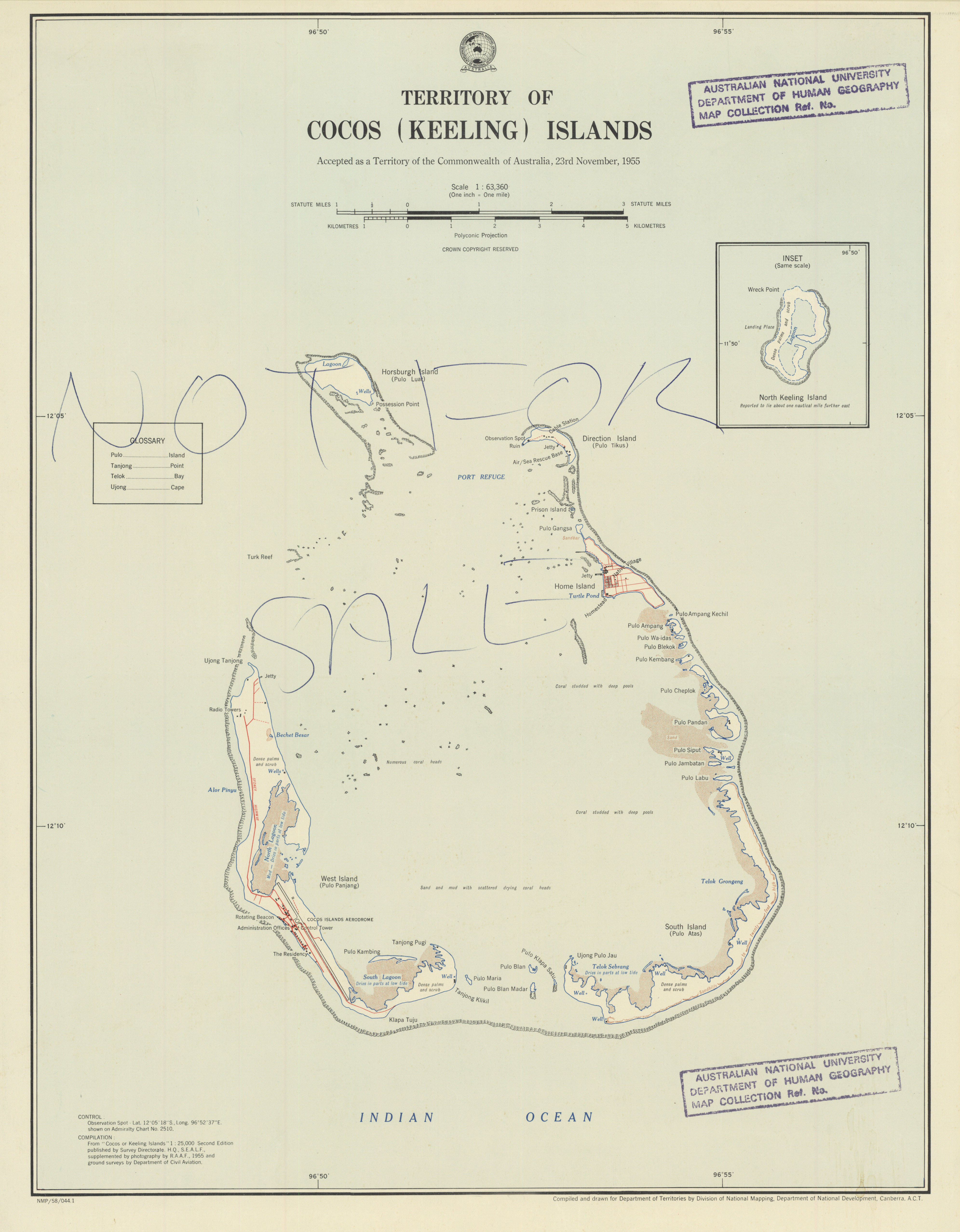 | |
| 6307_Australia__Territory of Cocos (Keeling) Islands_63.36K__master.tif | Preservation copy | 59.66 MB | TIFF |  |
Items in Open Research are protected by copyright, with all rights reserved, unless otherwise indicated.
Updated: 17 November 2022/ Responsible Officer: University Librarian/ Page Contact: Library Systems & Web Coordinator
+61 2 6125 5111
The Australian National University, Canberra
CRICOS Provider : 00120C
ABN : 52 234 063 906


